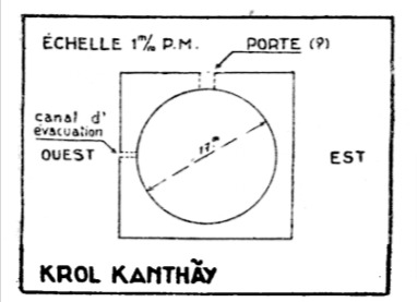
A partially cleared area where you can see the remains of a laterite wall. According to reports in the mid-1900s by Henri Mauger, the locals called it a turtle pit while he suggested it to be more likely for elephants or rhinoceros having the remains of an outer laterite wall with two openings enclosing a circular wall.
Reference
- Mauger Henri. Práh Khẵn de Kốmpon Svày. In: Bulletin de l’Ecole française d’Extrême-Orient. Tome 39, 1939. pp. 197-220; doi : https://doi.org/10.3406/befeo.1939.3722 https://www.persee.fr/doc/befeo_0336-1519_1939_num_39_1_3722
Map
*Important: mapped location may only be approximated to the district level/village only. To visit sites outside the tourist zones you should seek a local guide from the area read more.
Site Info
- Site Name: Kraol Kantheay Khmer Name: ក្រោលកន្ធាយ
- Reference ID: HA12271 | Posted: January 16, 2021 | Last Update: December 5th, 2021
- Tags/Group: PKKS, Temples
- Location: Preah Vihear Province > Sangkum Thmei District > Ronak Ser Commune > Ta Saeng Village
- MoCFA ID: 1161
- IK Number: 177.01


